
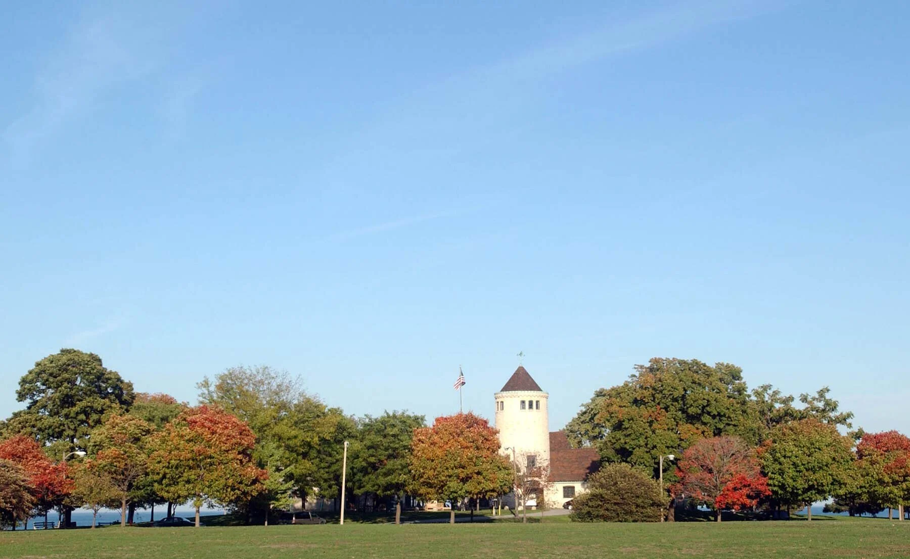
Promontory Point in autumn. Photo by Marc Monaghan.
Those of us who love Chicago history and architecture eagerly await October. This is when the Chicago Architecture Center presents Open House Chicago—an annual festival that provides behind-the-scenes tours of significant places throughout the city. This year, due to COVID-19, OHC has been reconfigured to offer self-guided driving, walking, and bicycling tours in 20 Chicago neighborhoods and two suburbs. From October 16 through 25, 2020, participants will have access to a free mobile app with tour materials that incorporate audio, images, and video. (openhousechicago.org) I helped develop some of these self-guided tours, including a “Hyde Park Innovation Trail.” My contribution is about Promontory Point, a 40-acre peninsula at the south end of Burnham Park, a lakefront park made entirely of landfill.
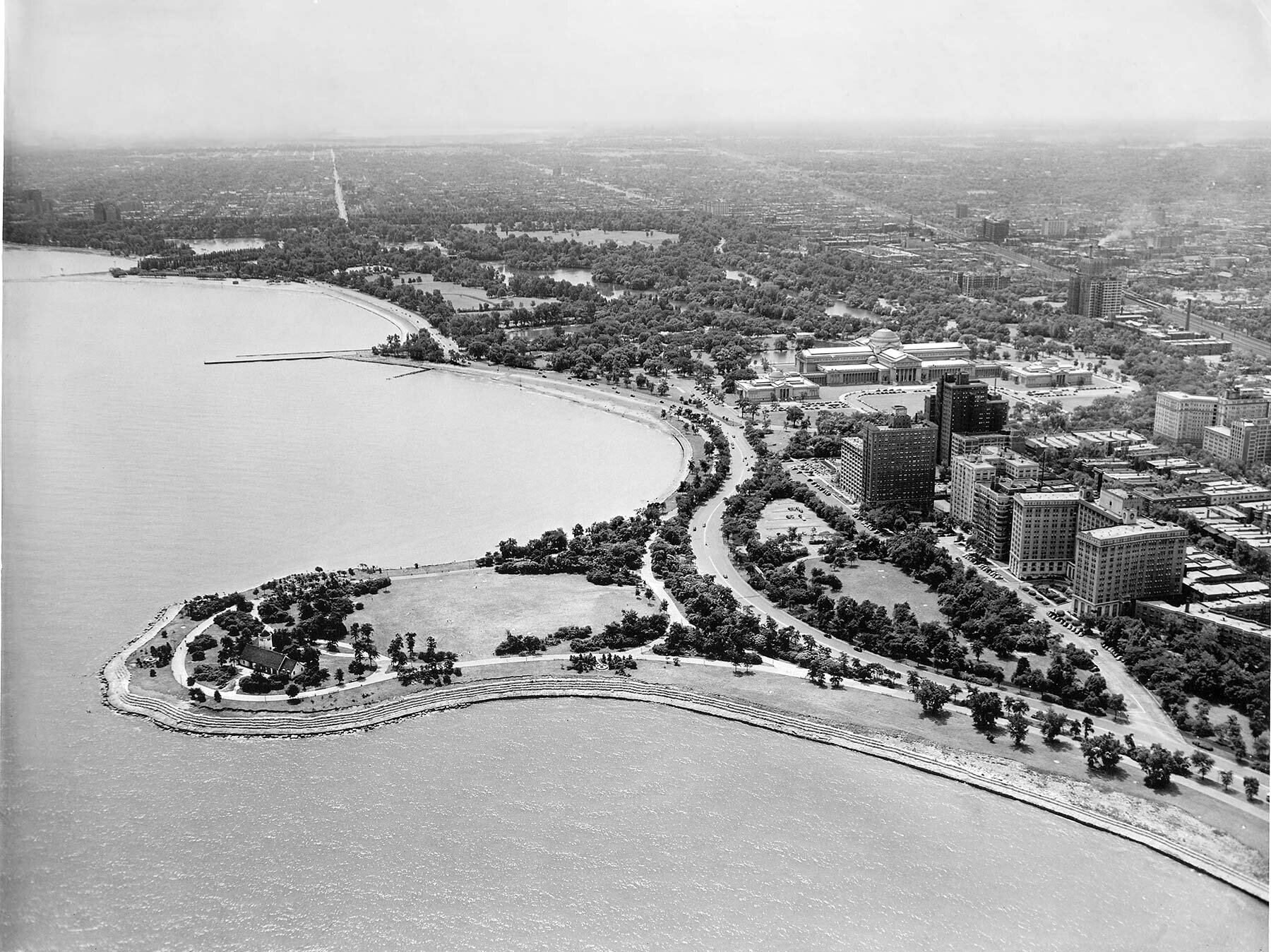
Aerial View of Promontory Point looking southwest, ca. 1940. Chicago Park District Records: Photographs, Special Collections, Chicago Public Library.

Aerial view of filling operations to create Promontory Point in Burnham Park, ca. 1930. Chicago Park District Records: Photographs, Special Collections, Chicago Public Library.
A few years ago, a community organization hired me to nominate Promontory Point to the National Register of Historic Places. The magnificent greenspace is well-deserving of its landmark status. It is a great addition to an OHC tour that highlights design and construction innovations. By the time Burnham Park was completed in the late 1930s, Chicago already had a 50-year history of creating new parkland using lake fill. But, by the Depression years, coastal engineering techniques for extending parks along the lakefront had become quite sophisticated.
The complicated method for creating lakefront parkland during the 1930s involved driving rows of enormous timber pilings into the bottom of Lake Michigan and then using steel rods to anchor and tie the pilings together. The resulting “cribs” were then filled with huge rocks. Tremendous quantities of fill such as construction debris were added between the cribs and the shoreline. Sand harvested from the bottom of the lake and from Indiana and Michigan was also used in the filling process.

View of Promontory Point from its Step Stone edge, 1940. Chicago Park District Records: Photographs, Special Collections, Chicago Public Library.
At Promontory Point, the entire peninsula was topped with black soil. To create an attractive outer edge that would withstand erosion, large limestone blocks were placed in a step-stone fashion along much of the park’s eastern perimeter. These step-stone revetments became an iconic part of Promontory Point’s landscape.

Family on step-stone revetments at Promontory Point. Photo by Marc Monaghan.
The initial idea for Promontory Point dates back to the early 20th century, when renowned architect and planner Daniel Hudson Burnham (1846–1912) was developing a visionary plan for Chicago’s lakefront. Having served as Director of Works for the World’s Columbian Exposition of 1893, Burnham proposed preserving part of Jackson Park’s fair site and creating a lakefront green space to stretch between the fairgrounds and downtown. He envisioned a long ribbon of greenspace with islands, a promontory, a harbor and lagoons, boat houses, bicycle paths, and a scenic roadway. This ambitious idea for new lakefront parkland became an important aspect of the 1909 Plan of Chicago, written by Daniel H. Burnham and Edward Bennett.

Burnham’s vision for a linear park along the lakefront between Grant and Jackson Parks included a peninsula at its south end. Plan of Chicago, 1909, Plate L.

Portrait of Daniel Hudson Burnham. Art Institute of Chicago.
Although Burnham’s proposal had broad support, the project proved to be extremely challenging. Not only would it be quite expensive, but, to move forward on the ambitious project, park administrators needed to secure riparian rights. They also had to obtain approvals from every level of government—even the Secretary of War, because Lake Michigan was a navigable body of water. These efforts were underway when Daniel H. Burnham died on June 1, 1912. The approvals were finally in place by 1920. That same year, Chicagoans voted in favor of a $20 million bond issue to fund the first phase of what would become the 600-acre park. Filling operations progressed slowly. In 1927, although the park was still largely unfinished, the South Park Commissioners named the new park in honor of Daniel Burnham.
The landfill project dragged on, and by the late 1920s, there was little progress south of E. 31st Street. By this time, Burnham Park had been selected as the site for Chicago’s second World’s Fair, A Century of Progress. As preparations for the fair were underway, filling operations accelerated. The fair opened in 1933 and was extended into a second season in 1934. Held at the height of the Great Depression, A Century of Progress gave fairgoers a sense of optimism about the future. The South Park Commission, the agency that managed Burnham Park, helped make the World’s Fair possible.

Aerial view of A Century of Progress, 1934, Chicago Park District Records: Photographs, Special Collections, Chicago Public Library.
The South Park Commission was one of 22 independent park districts operating contemporaneously in Chicago. All of these agencies were in financial crisis due to the Great Depression. To gain access to funding through President Franklin Delano Roosevelt’s New Deal, all 22 were consolidated into the Chicago Park District (CPD) in 1934. The CPD soon received substantial funding through the Works Progress Administration (WPA). Completing the 55th Street Promontory was an important priority for the CPD. Under the direction of its chief architect Emanuel V. Buchsbaum (1907-1995), plans were developed for a French eclectic style pavilion in the new park. The site’s general layout and plans for the building were developed in 1935.

Promontory Point Pavilion, 2017. Photo by Julia Bachrach.
In 1936, the CPD hired Alfred Caldwell (1903-1998), an extremely talented landscape architect who lacked academic credentials but was the protégé of the renowned Prairie style landscape designer Jens Jensen. Caldwell was put in charge of Promontory Point’s landscape. An architectural modernist, he believed that the pavilion was “too heavy for the site and of little architectural value.” Still, despite any negative opinions about this building or lack of input on its siting, Caldwell created a beautiful Prairie style landscape for the newly-made lakefront site. He designed a central meadow edged by shade trees and dense native understory plantings such as hawthorns, crab apples, American plum, prairie roses, serviceberries, sumac, viburnums, and American hazels.

Original hexagonal bench and path in Promontory Point. Chicago Park District Records: Photographs, Special Collections, Chicago Public Library.
In his plans for Promontory Point, Caldwell called for four council rings—the kind of beautiful circular stone benches that Jensen had often incorporated into his landscapes. Much to Caldwell’s chagrin, however, his CPD superiors changed his specifications and built concrete hexagonal benches instead. Caldwell’s plan included some stone paths that would lead to council rings. Some were built, but these looked a bit incongruous with the hexagonal concrete seats.

One of four council rings created in 1989 when Caldwell consulted on landscape improvements, 2017. Photo by Julia Bachrach.
Alfred Caldwell went on to have an illustrious career teaching at IIT and designing other significant landscapes, including a park for Lake Point Tower. Promontory Point fell into decline, and, for decades, Caldwell avoided visiting because he felt it would be too upsetting for him to see it in such a poor state. But that changed in 1989 when the CPD was in the midst of a reform effort and Caldwell was asked to consult on a restoration project for the Point’s landscape. Working closely with CPD landscape architects, Caldwell designed stone council rings to replace the four hexagonal benches that had been built without his input or approval. He also directed the selection and planting of 600 new native trees.

Sunday at the Point. Photo by Marc Monaghan.
I hope I’ve convinced you to participate in Open House Chicago tours this year. With luck, we can all go back to our regular way of touring next year. But in the meantime, visiting such glorious sites as Promontory Point with the help of the OCH materials will surely provide inspiration.