

Kathy Dickhut, and I will be team teaching a seminar at the Newberry Library this February. Photo by Robert Knapp
Happy New Year! I am pleased to announce that tomorrow, January 9, 2018, Early Bird Registration begins for a six-part seminar I will be teaching at the Newberry Library. Entitled Chicago Neighborhoods Then and Now, this series will explore the past, present, and future of three neighborhood clusters on the South, West, and Northwest Sides of the city. I will be team teaching this seminar with Kathy Dickhut, who has been a friend since our days in graduate school together in the department of Landscape Architecture at the University of Wisconsin. Kathy has had a long and distinguished urban planning career in Chicago. She is the Deputy Commissioner for Sustainability/Open Space at the Chicago Department of Planning and Development. This class size is limited because the Newberry Library is under renovations, so if you’re interested in attending our seminar, please register tomorrow.
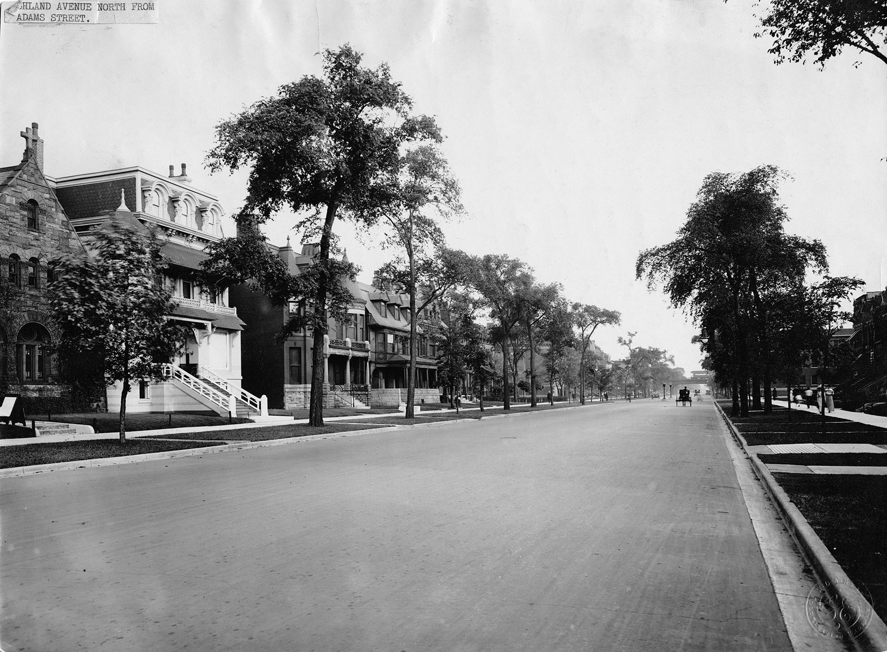
View of S. Ashland Avenue near W. Adams Street, ca. 1900. Photo courtesy of Chicago History Museum, iChi 27335.
Known as the “City of Neighborhoods,” Chicago is a tapestry of communities that are often in flux. Kathy and I will explore groupings of neighborhoods to better understand their histories, how and why they changed over time, and current visions and plans to improve them. On alternating weeks, I will provide insights into the history and development of the areas, and Kathy will focus on current conditions and illuminate plans and visions for the future.

Before and after photos of a vacant lot in Englewood that benefited from the City of Chicago’s Large Lots Program, 2017.

Landscape employees, construction stage, October 1891. Photograph by C.D. Arnold, Courtesy of Chicago Public Library, Special Collections, WCE CDA 11.53
I’d like to offer a few highlights from the first session, which will focus on several South Side neighborhoods. The decision by the US Congress in 1890 that would allow Chicago to host the World’s Columbian Exposition had a tremendous impact on these communities. Renowned landscape architect Frederick Law Olmsted and his partner, English architect Calvert Vaux, had created a magnificent plan in 1871 for the expansive South Park, a 1,055-acre site later known as Jackson and Washington Parks and the Midway Plaisance. Two decades later, Washington Park was essentially completed, while Jackson Park remained largely unimproved. Olmsted recommended Jackson Park as the site for the World’s Fair, not only to avoid destroying finished parkland for the fairgrounds, but also because it would have Lake Michigan as its backdrop. Working closely with Chicago’s famous architect and planner Daniel Hudson Burnham, Olmsted began to transform the swampy, unimproved Jackson Park site into the famous White City.

World’s Columbian Exposition, view south from Illinois Building, 1893. Photograph by C.D. Arnold, courtesy of Chicago Public Library, Special Collections, WCE CDA 9.10.
Nearby South Side communities such as Hyde Park, Woodlawn, Englewood, and Grand Boulevard had been annexed to Chicago in 1889 but still seemed like small villages a few years later. They began quickly transforming into urbane city neighborhoods when plans for the fair were announced. Because of the close proximity to the fairgrounds, speculators began purchasing lots and driving land costs up.

Stretch of 1890s row houses in Woodlawn, 2017. Photo by Adam Rubin.
Although multiple-family buildings had been erected in various parts of the city since the 1880s, middle- and upper-middle-class Chicagoans often had ambivalent feeling towards them. As historian Gwendolyn Wright explains in Building the American Dream: A Social History of Housing in America, many 19th century city dwellers feared that living in apartments would promote communism and promiscuity. For South Siders, these concerns were compounded by their awareness of the deplorable conditions of nearby Stockyards tenement districts. However, only the wealthiest South Siders could afford to build single-family homes in these desirable neighborhoods. Row houses provided a practical and attractive alternative. A row house not only occupied a smaller lot, it would also offer owners an individualized home with a handsome façade that might emulate the appearance of larger houses in the area.

Yale Apartment Hotel. Photo courtesy of Eric Alixx Rogers.
During the early 1890s, a new type of building, the apartment hotel, began to spring up in the neighborhoods near the fairgrounds. Englewood’s Yale Apartments at 6565 S. Yale Avenue is a significant extant example. Architect John T. Long designed the seven-story Romanesque Revival style building with a skylight and interior atrium to help 19th-century residents get over their fears related to living in an apartment. Many other apartment structures soon went up throughout the South Side, providing middle-class Chicagoans opportunities to live in neighborhoods that might otherwise be unobtainable to them.
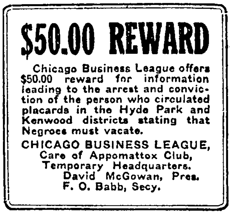
“Display Ad 1,” Chicago Defender, November 29, 1919.
During the 1910s, many members of Chicago’s growing African-American community sought to live in neighborhoods such as Hyde Park and Woodlawn. The city’s black population of 40,000 in 1910 had more than doubled a decade later, during the early years of the Great Migration. A large percentage of the African-American population was concentrated in the Grand Boulevard neighborhood (also called Bronzeville). African-Americans who had escaped the Jim Crow South often found good jobs in Chicago, but when they aspired to buy or rent in neighborhoods just south of Bronzeville, they were generally met with resistance, animosity, and even violence from white residents. According to the Negro in Chicago, a major study published in 1922 by the Illinois Commission on Race Relations, the Hyde Park Kenwood Property Owners’ Association launched a vitriolic campaign to “make Hyde Park white.”

In 2009, Mike Torney and his students from York High School in Elmhurst, IL, underwrote and dedicated a plaque at Chicago’s 31st Street Beach commemorating the lives of the victims of Chicago’s Race Riot.
In the summer of 1919, when Eugene Williams, an African-American boy, was rafting from a South Side beach and inadvertently drifted across an invisible racial boundary barrier, white men threw rocks at him, and he drowned. Five days of terrible rioting erupted, leaving 500 people injured and 38 dead.
By the early 1920s, a small number of middle-class African-Americans had managed to purchase homes in a part of Woodlawn called the Washington Park Subdivision. In 1928, when additional blacks tried to settle there, owners within a 24-block area signed a covenant restricting the rental or sale of property to “colored families.” The Woodlawn Property Owners’ Association filed this restrictive covenant with the county recorder. A Chicago Defender article entitled “Property War Looms: South Siders Get New Jim Crow Laws” reported that this filing followed “closely in the footsteps of white fanatics who operated under the name of the Kenwood and Hyde Park Protective Association.”

Brick three-flat purchased by Carl Hansberry in 1937. Photo courtesy of WTTW.
The financial strains of the Great Depression prompted many white landlords to ignore the expansive Woodlawn covenant. They illegally subdivided apartments and rented substandard units to African-Americans who were desperate to find housing. In 1937, Carl Hansberry, a successful African-American real estate, purchased a three-flat in at 6140 S. Rhodes. Neighboring property owners in the Washington Park Subdivision soon filed an injunction to uphold the covenant restricting African-Americans from living in the neighborhood despite the fact that the Hansberry held legal title to the property. His daughter, playwright Lorraine Hansberry (1930 – 1965), based her award-winning play, A Raisin in the Sun, on the trauma she and her family experienced as her father waged a three-year-long legal battle against racially restrictive housing practices.
In 1948, the US Supreme Court determined that the enforcement of racial housing covenants was illegal. While efforts in some South Side neighborhoods sought to manage racial integration in the 1950s and early 1960s, various forces destabilized neighborhoods such as Woodlawn and Englewood. In our Newberry Library class, Kathy Dickhut will better explain these issues, as well as current plans to revitalize these communities in need.